
Take action to strengthen the MoCo Forest Conservation Law
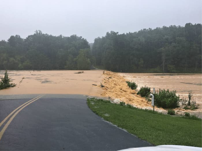
Sediment-laden flood waters entering the Little Seneca Reservoir, July 8 2019 (Photo credit: Montgomery Parks)
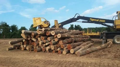
Forest clearing in the Cabin Branch watershed - over the ridge from Ten Mile Creek watershed (Photo credit: Miriam Schoenbaum)
While forests in the Ten Mile Creek watershed are designated for protection under the 2014 Ten Mile Creek Amended Master Plan, neighboring watersheds, which also drain to the Little Seneca Reservoir, are hotspots of deforestation in the County. The impacts of forest loss become most visible during heavy rainstorms when tributary streams load more sediment and nutrient pollution into this emergency backup Reservoir - a 2015 study found the rate of sediment accumulation in Little Seneca is almost twice as high as in comparable drinking water reservoirs in Maryland (those found in 3rd and 5th order watersheds) - after deducting the estimated amount that could be attributed to construction when sediment loads are highest. And streams from all up-county watersheds enter the Potomac River nearby and upstream from our drinking water intake carrying stormwater runoff and sediment from land erosion and scoured stream beds, which increases the cost of water treatment for everyone. Forests also have numerous other benefits for the quality of life, which include carbon sequestration, reducing the urban heat island effect, purifying the air and the water we drink, and providing green spaces that are important for human health. In other words, they are part of the critical natural infrastructure that supports more than our water supply.
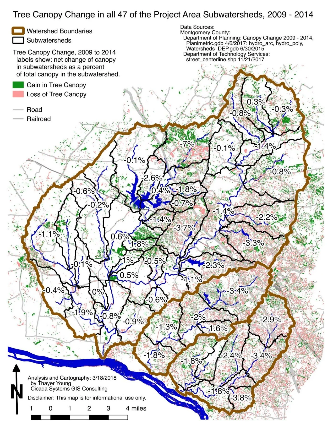
Forest Loss in three upper Montgomery County watersheds, 2009-2014. Source: Cameron et al 2017
Overall, the County lost 1,383 acres of forests from 2008 to 2016, the fifth highest rate of loss in the state. Global Forest Watch estimates a 1.5% decrease from 2000 to 2020, amounting to 2352 acres, adding 322 kt of greenhouse gas emissions to the atmosphere. As shown in the map below, the rate of deforestation in the Clarksburg watershed was near 7% from 2009 to 2014, which is twice as high as any other single place in the county (1). A current Planning Department map of pending development plans in the county suggests this trend continues unabated (2).
In response, the Montgomery County Forest Coalition - which includes Friends of Ten Mile Creek, initiated an effort to strengthen the County's Forest Conservation Law in Summer 2020. The Coalition initially asked the County Council to add a "No Net Loss of Forests" provision to a related bill. Needing more time to consider the Coalitions recommendations, the Council indicated they would address these in 2021. In the meantime, the Coalition continued to meet with members of the Council, their staff, and Planning Department staff and provided specific recommendations. In response to our advocacy, the Planning Department also developed a "No Net Loss of Forests" initiative in November 2021 and has just developed a draft bill that partially adopts one of the Coalition recommendations, but falls well short of achieving No Net Loss.
Coalition recommendations, if adopted, would:
Protect existing forests by designating them as priority forests. These could not be removed without approval of the Planning Director based on appropriate justification.
Give a higher level of protection to certain types of forest, which could only be removed if a Variance is granted and would need to be replaced at a ratio of 2:1. These types would include Floodplains; Stream Buffers; Forested Stream Buffers along Ephemeral Streams; Steep Slopes; Critical Habitats; Contiguous Forests; Forest Connective Corridors; Rare, Threatened, & Endangered Species habitat; Historic Site trees; Champion Trees and other exceptionally large trees; and areas designated as “Priority Save Areas” in Master Plan or any Functional Plan.
Strengthen required replanting ratios from 1/4 acre planted for every acre removed to 2 acres for each acre removed, with no credit for forests retained.
If state law were to again allow credits for retention of existing forests in mitigation banks, require that at least 1/4th of the requirement is met through planting additional forest. If the mitigation bank is outside the watershed where forest is removed, the ratio would increase from 2:1 to 4:1.
As much as possible, it would require not only replanting of trees but also practices that help restore the forest ecosystems to the extent possible. This implies the need to also implement measures to restore soil health; fungi and healthy micro-biotic communities in the soil; drainage patterns; biomass; groundcover; shrub, understory and tree canopy layers, and diversity of different types of trees and plants.
Require delineation of forests prior to submitting application plans to develop a site.
This effort is just a start. In Montgomery County, the Forest Conservation Law only addresses loss of forests associated with development on large tracts, over 40,000 square feet. To reduce loss of forests and tree canopy in existing neighborhoods it will be necessary to also strengthen the Tree Canopy Law and the Roadside Tree Protection Law. Howard, Anne Arundel and Frederick Counties have already strengthened their local forest conservation laws. In Frederick County, the County Council unanimously passed a bill that mandates "no net loss" of trees. Another attempt to strengthen the Maryland state Forest Conservation Act is expected next year.
More information can be found on the ANS blog where you can also demonstrate your support by signing-on to the MoCo Forest Coalition Statement of Principles. Through a separate Action Alert, you can also send letters to the Montgomery County asking that they introduce and pass legislation consistent with these principles.
References
(1) Cameron, D., Tognetti S., and Young T. 2017. Protecting the Source and Maintaining Water Affordability. Report prepared for MD Sierra Club by the Ecologix Group.
(2) A County map of Pending and Recent Project approvals shows 105 projects within a 5 mile radius of the Pulte plan, all to the east of the Ten Mile Creek watershed